Weed Mapping
Aquatic Invasive species Surveys & Mapping
As part of the Wapato Revival’s call for prioritization and strategic weed management, regular monitoring and data collection will continue to play a role in how WAIN professionals dedicate resources for treatment, for which species, and where. In addition to holding seasonal ID workshops to help train new field staff and volunteers, WAIN captures data about AIS and native aquatic species of interest. This effort has been conducted via the Fulcrum Community AIS smartphone application in the past. We are currently migrating our efforts to a new platform for 2022. Check back soon for updates.
If you would like to participate in the effort to crowd source AIS distribution data, please send us a message.
Data collected by WAIN partners and volunteers includes the following:
- Observer’s name
- Observation date
- Species observed or surveyed
- Phenological stage of the plant
- Patch size (choose among provided size categories)
- Coverage and distribution of AIS within the patch
- Habitat type
- Sediment characteristics
- Whether the plants were hand pulled
- Site hazards (related to accessing the site from the navigable waterway)
- General notes about the observations
- Site and plant photos
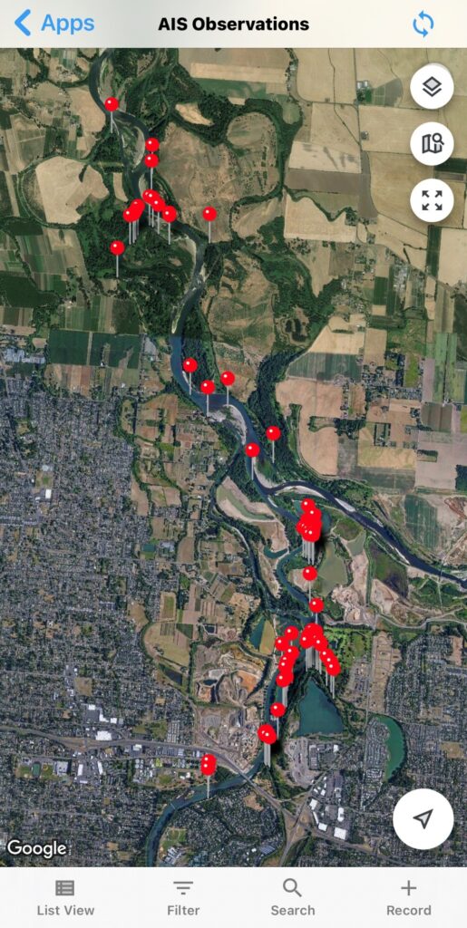
View our Current survey Data
Click on the markers in the map below to view up-to-date AIS observations from our database. These reports are added in real time, but in some locations without internet connection, the upload will be delayed. Use the plus and minus icons in the upper left (or CTL+SCROLL) to zoom in and out. Click and drag to pan around the map.
Please check back as data access from this website will be available in the near future. Data will be updated regularly as it is synced through observations in the field and automatically updated to the website through a weekly process. Users will be able to search and sort data into heat maps or layers, by date, species, geographic area, and more.
other survey Data
While members of WAIN have used Fulcrum for monitoring and updating weed populations before and after treatment – we recognize that many organizations already have tools in place for this purpose, including the ODA WeedMapper, USGS Nonindigenous Aquatic Species (USGS NAS) database, and the Institute for Natural Resources iMapInvasives program. When Fulcrum cannot be used, professionals are encouraged to share GIS and non-GIS digital information. To improve aquatic invasive species GIS data sharing in the Willamette Basin and realize additional, collective value from all of our individual, programmatic invasive species data collection efforts occurring in the WAIN project area, please support our data sharing goals by following the Data Sharing Protocol.